The Indian Army already considers Google Earth a threat to National Security but this free and useful 3D geographic imaging software is turning out to be a bigger threat to the Indian state governments now.
First, it was the Maharashtra famers who used satellite images from Google Earth to prove that their government was providing inadequate compensation for an otherwise fertile land.
Now, it's the Andhra government who seems to be in the soup courtesy Google Earth.
The opposition party in the southern Indian state of Andhra Pradesh have alleged that leaders of the ruling party have acquired land worth $1.65 billion in the recent years. [not for UTube]
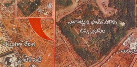
When this charge was denied by the government, the opposition downloaded satellite images from Google Earth dating back to 2004 which showed that there were no structures built on those pieces of land and the construction was done only recently.
Now the Government says these images are tailored. B V Harish has the complete background and the scanned image from the newspaper.
